Machu Picchu is a 15th-century Inca site located 2,430m above sea level in the Cusco Region, Urubamba Province, Machupicchu District in Peru. It is situated on a mountain ridge above the Sacred Valley which is 80km northwest of Cusco and through which the Urubamba River flows. Most archaeologists believe that Machu Picchu was built as an estate for the Inca emperor Pachacuti (1438–1472). Often mistakenly referred to as the "Lost City of the Incas", it is perhaps the most familiar icon of Inca civilization.

The Incas built the estate around 1450, but abandoned it a century later at the time of the Spanish Conquest. Although known locally, it was unknown to the outside world before being brought to international attention in 1911 by the American historian Hiram Bingham. Since then, Machu Picchu has become an important tourist attraction. Most of the outlying buildings have been reconstructed in order to give tourists a better idea of what the structures originally looked like. By 1976, thirty percent of Machu Picchu had been restored. The restoration work continues to this day.
Machu Picchu was built in the classical Inca style, with polished dry-stone walls. Its three primary structures are the Inti Watana, the Temple of the Sun, and the Room of the Three Windows. These are located in what is known by archaeologists as the Sacred District of Machu Picchu.

The site is roughly divided into an urban sector and an agricultural sector, as well as the upper town and the lower town. The temples are part of the upper town, the warehouses the lower.
The architecture is adapted to the natural form of the mountains. Approximately 200 buildings are arranged on wide parallel terraces around a vast central square that is oriented east-west. The various kanchas or compounds are long and narrow in order to exploit the terrain. Extensive terraces were used for agriculture and sophisticated channeling systems provided irrigation for the fields. Numerous stone stairways set in the walls allowed access to the different levels across the site. The eastern section of the city was probably residential. The western, separated by the square, was for religious and ceremonial purposes. This section contains the Torreón, the massive tower which may have been used as an observatory
.jpg)
The Inti Watana stone is one of many ritual stones in South America. These stones are arranged to point directly at the sun during the winter solstice. The name of the stone (coined perhaps by Bingham) is derived from the Quechua language: inti means "sun", and wata- is the verb root "to tie, hitch (up)". The Quechua -na suffix derives nouns for tools or places. Hence inti watana is literally an instrument or place to "tie up the sun", often expressed in English as "The Hitching Post of the Sun". The Inca believed the stone held the sun in its place along its annual path in the sky. The stone is situated at 13°9'48" S. At midday on 11 November and 30 January the sun stands almost above the pillar, casting no shadow at all. On 21 June the stone is casting the longest shadow on its southern side and on 21 December a much shorter one on its northern side. Researchers believe that it was built as an astronomic clock or calendar.


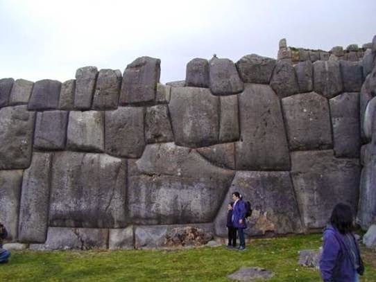
The section of the mountain which Machu Picchu was built on provided several beneficial and detrimental factors. The most apparent detriment was that Machu Picchu was built between two fault lines. This location also frequently received heavy rainfall; this meant that land and mud slides in the area were also common. The Inca needed a solution to these detriments, and Machu Picchu would offer everything they needed.
The seismic activity which is caused by being between two fault lines led the use of mortar and other such building materials to be nearly useless. However, the Inca developed a successful method which allowed the construction of Machu Picchu to be possible. The site offered a natural quarry which was used to construct the over 200 buildings which would sit on the mountaintop. The stones harvested from this quarry were lined up, and shaped to perfectly fit together in a manner which would supply a more sturdy method than mortar would have. However, the Inca would also use the chips which they carved off of the stones in their construction and as a method to avoid mud and landslides, as well as flooding.


These stone chips were used in the terraces and in the large courtyard in the center of Machu Picchu. The terraces were used chiefly to drain and syphon the water from rain, as well as to hold the mountain in place. Each terrace was multi layered: first top soil, then dirt, sand and finally stone chips. This meant that water which sat on the terraces would sift downward into the mountain, as opposed to overflowing and running down the mountain.


Inca walls had numerous design details that helped protect them against collapsing in an earthquake. Doors and windows are trapezoidal and tilt inward from bottom to top; corners usually are rounded; inside corners often incline slightly into the rooms; and "L"-shaped blocks often were used to tie outside corners of the structure together. These walls do not rise straight from bottom to top, but are offset slightly from row to row.
The Incas never used the wheel in any practical manner. Its use in toys demonstrates that the principle was well-known to them, although it was not applied in their engineering. The lack of strong draft animals, as well as steep terrain and dense vegetation issues, may have rendered the wheel impractical. How they moved and placed the enormous blocks of stones remains a mystery, although the general belief is that they used hundreds of men to push the stones up inclined planes. A few of the stones still have knobs on them that could have been used to lever them into position; it is believed that after the stones were placed, the Incas would have sanded the knobs away, but a few were overlooked.


.jpg)


No comments:
Post a Comment